MoPac South Environmental Study
THE PROBLEM
The MoPac Expressway south of Cesar Chavez Street is a vital artery for Austin commuters and neighbors, as well as visitors to our region. This corridor provides a critical link to downtown Austin and other major highways such as US 290 and Loop 360/Capital of Texas Highway, and it provides access to neighborhoods, schools, businesses, parks and trails, recreational centers and commercial areas. Consistently ranked as one of the most congested roadways in Texas, it attracts up to 180,000 cars and trucks per day. Over time, expanding population as well as residential, retail and commercial development in the corridor, has led to increased traffic congestion. This negatively impacts mobility and quality of life for the traveling public and adjacent neighborhoods.
IDENTIFYING A SUSTAINABLE SOLUTION
In 2013, the Central Texas Regional Mobility Authority (Mobility Authority) and the Texas Department of Transportation (TxDOT) initiated an Environmental Study of the MoPac corridor from Cesar Chavez Street to Slaughter Lane to determine the best alternatives for improving mobility and safety.
A full range of alternatives were developed that considered the needs of drivers, transit riders, bicyclists and pedestrians, as well as surrounding businesses, neighborhoods and the environment. Extensive analysis of engineering feasibility as well as social, economic and environmental impacts of each alternative was conducted. Through that analysis, the study identified the Express Lane(s) Alternative as the Reasonable Build Alternative.
Six Operational Configuration Options of the Express Lane(s) Alternative were analyzed:
- 1A: One Express Lane with Downtown Direct Connection
- 1B: One Express Lane without Downtown Direct Connection
- 2A: Two Express Lanes with Downtown Direct Connections
- 2B: Two Express Lanes without Downtown Direct Connections
- 2C: Two Express Lanes with Elevated Ramps near Barton Skyway
- 3: City of Austin Proposal
The 2C Configuration, Two Express Lanes with Elevated Ramps near Barton Skyway, is the Recommended Build Alternative. It includes one express lane from Cesar Chavez to Barton Skyway, two express lanes from Barton Skyway to Convict Hill Road, and one express lane from Convict Hill Road to Slaughter Lane.
Analysis of the six Operational Configuration Options using the evaluation criteria vetted by the public helped inform the decision. The 2C configuration delivered the most improvement in operational efficiencies and hours of delay saved; the configuration does not include elevation over Lady Bird Lake and uses no additional right-of-way, priorities shared by the public; the wishbone ramps eliminate weaving, improving operations and safety, and allows for multiple downtown exit options; and the configuration had fewer impacts than options 1A, 2A, and 3.
Throughout the process, the community was and will continue to be asked to share opinions on a wide range of topics, including:
- Need and purpose for improvements to MoPac Expressway
- Alternatives and roadway design
- Bicycle and pedestrian accommodations
- Corridor aesthetics
- Neighborhood access and connectivity
Because the corridor is located within the Barton Springs segment of the Edwards Aquifer Recharge Zone, any potential project-related impacts to water quality are being carefully considered.
The study team also initiated a Context Sensitive Solutions (CSS) process, so that the proposed mobility improvements not only meet the needs of the community served, but fit into the physical setting and reflect the scenic, aesthetic, historic and environmental resources of the region.
THE PROCESS
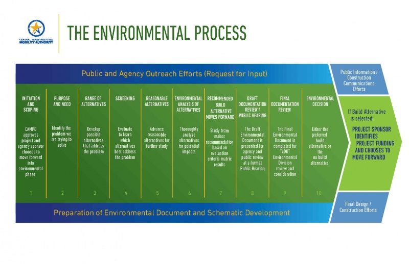
ENVIRONMENTAL PROCESS
Click on the image below to learn more about the Environmental Process we follow.
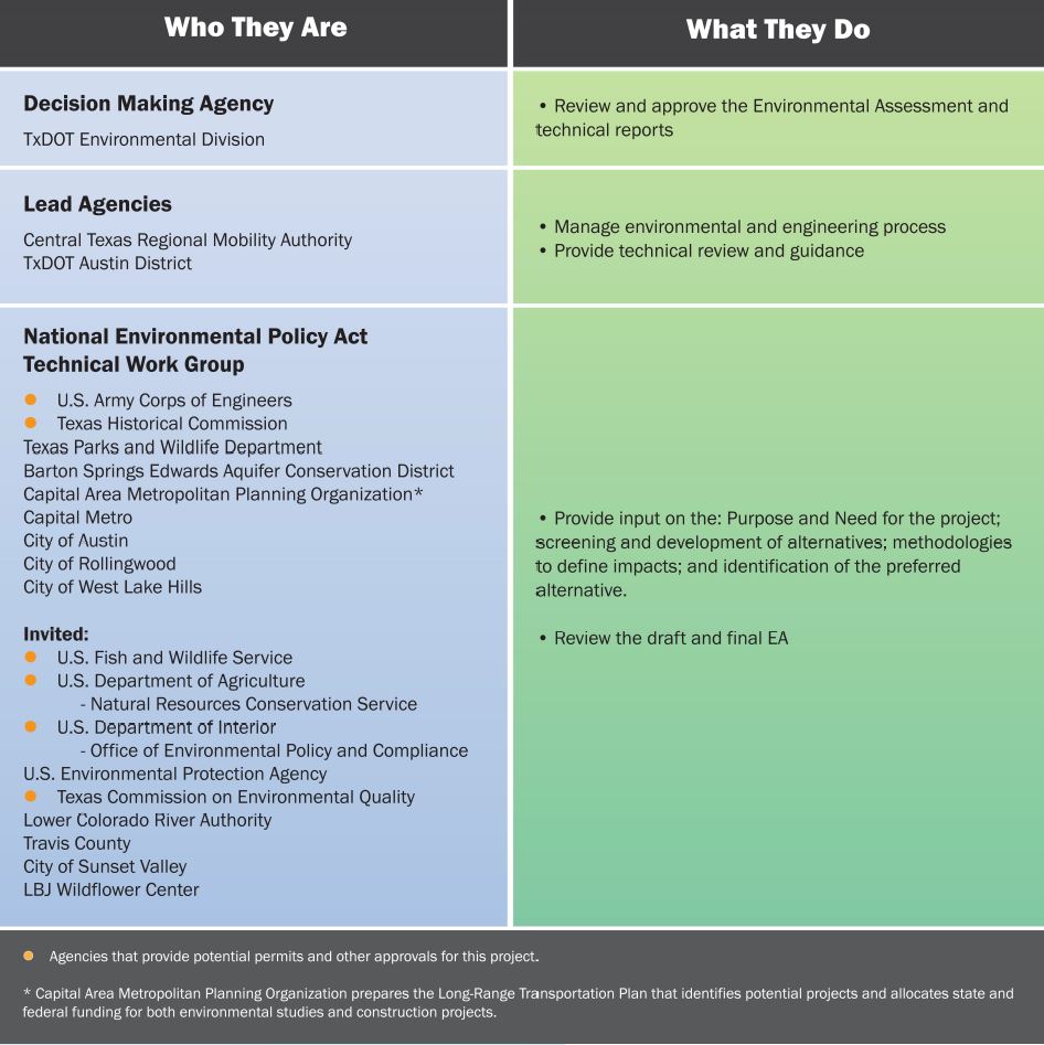
 AGENCIES AND THEIR ROLES IN THE ENVIRONMENTAL PROCESS
Many agencies participate in the development of an Environmental Study at local, state and federal levels. This chart identifies the agencies that participate in the MoPac South Environmental Study and explains how each contributes. It also identifies how the community can participate in the study.